
Bestand:Sakarya districts.png
Grootte van deze voorvertoning: 778 × 600 pixels. Andere resoluties: 311 × 240 pixels | 623 × 480 pixels | 996 × 768 pixels | 1.053 × 812 pixels.
Oorspronkelijk bestand (1.053 × 812 pixels, bestandsgrootte: 88 kB, MIME-type: image/png)
Beschrijving
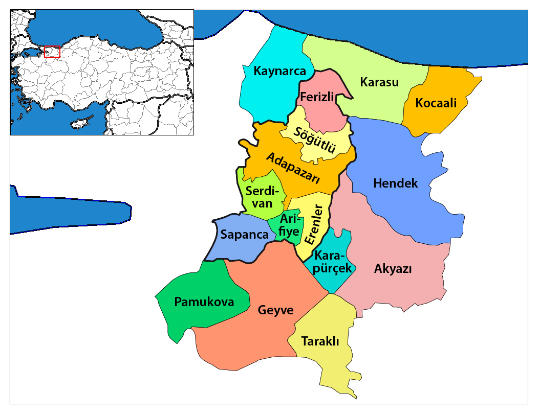
| Beschrijving | Map of the districts of Sakarya province in Turkey. Created by Rarelibra 17:12, 4 December 2006 (UTC) for public domain use, using MapInfo Professional v8.5 and various mapping resources. Edited by One Homo Sapiens Corrected text where İ,Ş,ı,ğ,or ş occurs in name. Source: [statoids-com]. Increased font size and enhanced color differences among adjacent districts. |
| Datum | 4 december 2006 (originele uploaddatum) |
| Bron | Geen machineleesbare bron opgegeven. Eigen werk aangenomen (gebaseerd op auteursrechtclaims). |
| Auteur | Geen machineleesbare auteur aanwezig. Op basis van auteursrechtclaims wordt auteur Rarelibra aangenomen. |
Licentie
| Ik, de auteursrechthebbende van dit werk, geef dit werk vrij in het publieke domein. Dit is wereldwijd van toepassing. In sommige landen is dit wettelijk niet mogelijk; in die gevallen geldt: Ik sta iedereen toe dit werk voor eender welk doel te gebruiken, zonder enige voorwaarden, tenzij zulke voorwaarden door de wet worden voorgeschreven. |
Bestandsgeschiedenis
Klik op een datum/tijd om het bestand te zien zoals het destijds was.
| Datum/tijd | Miniatuur | Afmetingen | Gebruiker | Opmerking | |
|---|---|---|---|---|---|
| huidige versie | 19 jan 2014 20:47 | | 1.053 × 812 (88 kB) | Chumwa | Nach der letzten Gebietsreform ist der zentrale Landkreis (in der Karte zuvor "Sakarya Merkez") aufgeteilt worden in: Adapazarı, Arifiye, Erenler und Serdivan. Die Kreise, die zur Großstadtkommune Sakarya gehören, sind umrandet worden. |
| 29 dec 2008 03:58 |  | 1.056 × 816 (33 kB) | One Homo Sapiens | Corrected text where İ,Ş,ı,ğ,or ş occurs in name. Source: [statoids-com]. Increased font size and enhanced color differences among adjacent districts. | |
| 12 apr 2007 18:00 |  | 776 × 600 (110 kB) | KureCewlik81 | ||
| 4 dec 2006 19:12 |  | 1.056 × 816 (34 kB) | Rarelibra | Map of the districts of Sakarya province in Turkey. Created by ~~~~ for public domain use, using MapInfo Professional v8.5 and various mapping resources. |
Bestandsgebruik
Dit bestand wordt op de volgende 15 pagina's gebruikt:
Globaal bestandsgebruik
De volgende andere wiki's gebruiken dit bestand:
- Gebruikt op ar.wikipedia.org
- Gebruikt op arz.wikipedia.org
- Gebruikt op ast.wikipedia.org
- Gebruikt op azb.wikipedia.org
- Gebruikt op az.wikipedia.org
- Gebruikt op be.wikipedia.org
- Gebruikt op ca.wikipedia.org
- Gebruikt op ceb.wikipedia.org
- Gebruikt op ce.wikipedia.org
- Gebruikt op cs.wikipedia.org
- Gebruikt op cv.wikipedia.org
- Gebruikt op de.wikipedia.org
- Gebruikt op diq.wikipedia.org
- Gebruikt op en.wikipedia.org
Globaal gebruik van dit bestand bekijken.


