
Bestand:Portugaliza map-fr.svg

Afmetingen van deze voorvertoning van het type PNG van dit SVG-bestand: 275 × 599 pixels Andere resoluties: 110 × 240 pixels | 220 × 480 pixels | 353 × 768 pixels | 470 × 1.024 pixels | 941 × 2.048 pixels | 1.739 × 3.785 pixels.
Oorspronkelijk bestand (SVG-bestand, nominaal 1.739 × 3.785 pixels, bestandsgrootte: 1,55 MB)
Beschrijving
| Beschrijving |
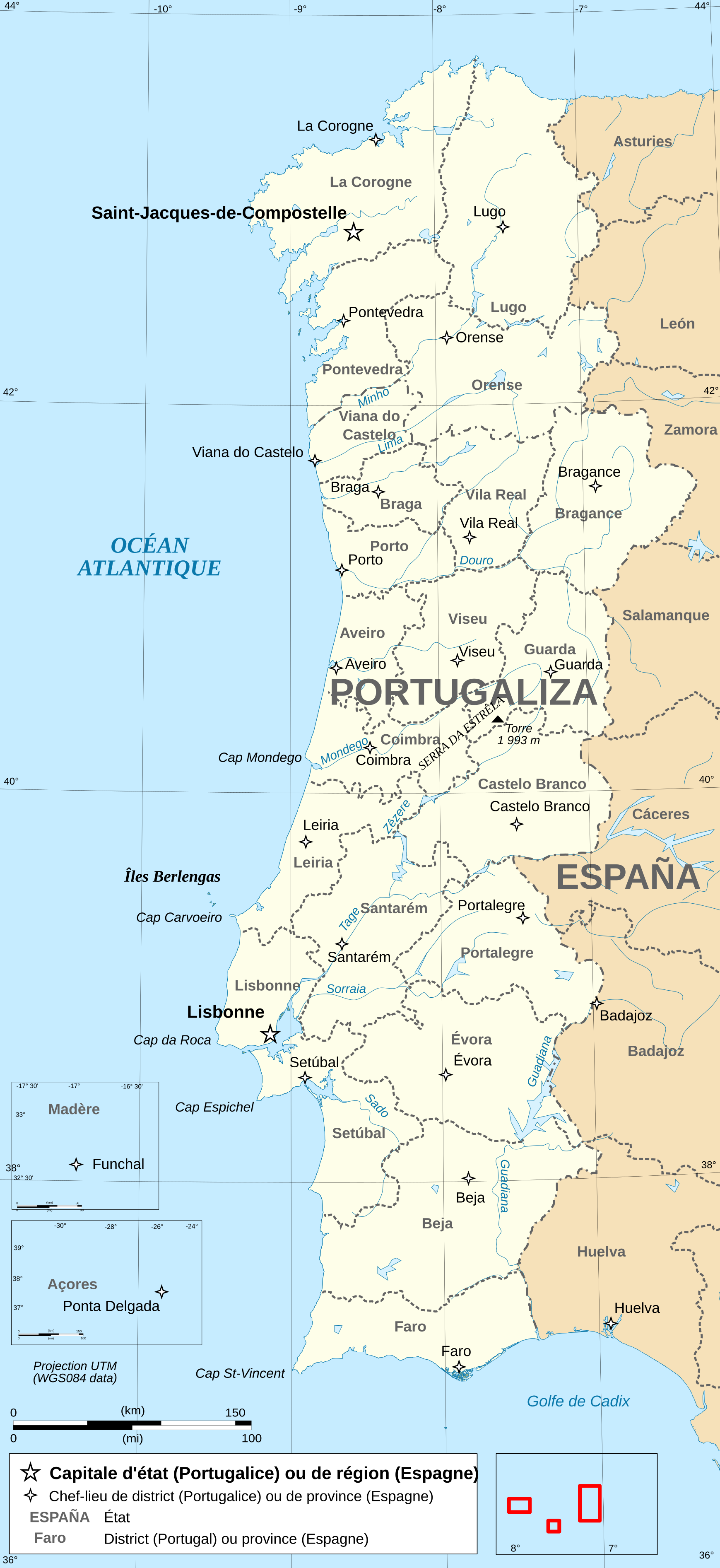
Français : Carte administrative en français de la Portugalice. Português: Carta da administração do Portugaliza Galego: Mapa de Portugaliza Deutsch: Karte von Portugalicien, französische Version English: Administrative map in French of Portugalicia Español: Mapa administrativo en francès de Portugalicia Italiano: Carta amministrativa de Portugalizia |
| Datum | |
| Bron | travail personnel (own work), from File:Portugal administrative map-fr.svg by uploader. Same sources for Galicia add. |
| Auteur | Bourrichon |
Licentie
Ik, de auteursrechthebbende van dit werk, maak het hierbij onder de volgende licenties beschikbaar:

|
Toestemming wordt verleend voor het kopiëren, verspreiden en/of wijzigen van dit document onder de voorwaarden van de GNU-licentie voor vrije documentatie, versie 1.2 of enige latere versie als gepubliceerd door de Free Software Foundation; zonder Invariant Sections, zonder Front-Cover Texts, en zonder Back-Cover Texts. Een kopie van de licentie is opgenomen in de sectie GNU-licentie voor vrije documentatie. |
Dit bestand is gelicenseerd onder de Creative Commons-licenties Naamsvermelding-Gelijk delen 3.0 Unported, 2.5 Algemeen, 2.0 Algemeen en 1.0 Algemeen.
- De gebruiker mag:
- Delen – het werk kopiëren, verspreiden en doorgeven
- Remixen – afgeleide werken maken
- Onder de volgende voorwaarden:
- naamsvermelding – U moet op een gepaste manier aan naamsvermelding doen, een link naar de licentie geven, en aangeven of er wijzigingen in het werk zijn aangebracht. U mag dit op elke redelijke manier doen, maar niet zodanig dat de indruk wordt gewekt dat de licentiegever instemt met uw werk of uw gebruik van zijn werk.
- Gelijk delen – Als u het werk heeft geremixt, veranderd, of erop heeft voortgebouwd, moet u het gewijzigde materiaal verspreiden onder dezelfde licentie als het oorspronkelijke werk, of een daarmee compatibele licentie.
U mag zelf één van de licenties kiezen.
Bestandsgeschiedenis
Klik op een datum/tijd om het bestand te zien zoals het destijds was.
| Datum/tijd | Miniatuur | Afmetingen | Gebruiker | Opmerking | |
|---|---|---|---|---|---|
| huidige versie | 5 feb 2019 04:17 | | 1.739 × 3.785 (1,55 MB) | Tuvalkin | Corr. retângulo vermelho do mapa loc.; rmv. "ESPAGNE" sobre terr. galego; trad. top. nacionais. Rmv. tb imagens ráster. |
| 28 apr 2009 20:04 |  | 1.739 × 3.785 (6,57 MB) | Bourrichon | key | |
| 26 apr 2009 02:04 |  | 1.739 × 3.785 (6,57 MB) | Bourrichon | + "Portugal" | |
| 26 apr 2009 00:29 |  | 1.739 × 3.785 (6,57 MB) | Bourrichon | {{Information |Description={{fr|Carte administrative en français de la Portugalice.}}{{po|Carta da administração do Portugaliza}}{{gl|Portugaliza}}{{de|Karte von [[:de:Portugalicien|Portugalic |
Bestandsgebruik
Dit bestand wordt op de volgende pagina gebruikt:
Globaal bestandsgebruik
De volgende andere wiki's gebruiken dit bestand:
- Gebruikt op ast.wikipedia.org
- Gebruikt op ca.wikipedia.org
- Gebruikt op es.wikipedia.org
- Gebruikt op fi.wikipedia.org
- Gebruikt op fr.wikipedia.org
- Gebruikt op hy.wikipedia.org
- Gebruikt op tr.wikipedia.org


