
Bestand:Montreal1764CedarsDetail.png

Grootte van deze voorvertoning: 800 × 523 pixels. Andere resoluties: 320 × 209 pixels | 640 × 418 pixels | 1.067 × 697 pixels.
Oorspronkelijk bestand (1.067 × 697 pixels, bestandsgrootte: 1,19 MB, MIME-type: image/png)
Beschrijving
| Beschrijving |
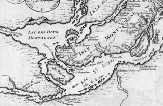
English: This is a detail of the original source map, cropped to depict the western part of the Isle of Montreal and immediately surrounding mainland as far as Les Cèdres. The map's caption reads "Montreal et ses Environs" (Montreal and its environs). It depicts a number of places relevant to the 1776 Battle of the Cedars. |
| Datum | |
| Bron | Bibliothèque Nationale de France http://gallica2.bnf.fr/ark:/12148/btv1b67001778 |
| Auteur | Bellin, Jacques-Nicolas, for the Kingdom of France |
| Andere versies | IsleDeMontreal1764.png |
Licentie
|
Dit werk bevindt zich in het publiek domein in landen en gebieden waar de auteursrechttermijn het leven van de auteur plus 100 jaar of minder is. | |
| Van dit bestand is vastgesteld dat er geen bekende auteursrechtaanspraken op rusten, alle aanverwante en naburige rechten daarbij inbegrepen. | |
Bestandsgeschiedenis
Klik op een datum/tijd om het bestand te zien zoals het destijds was.
| Datum/tijd | Miniatuur | Afmetingen | Gebruiker | Opmerking | |
|---|---|---|---|---|---|
| huidige versie | 24 jan 2009 00:57 | | 1.067 × 697 (1,19 MB) | Magicpiano | {{Information |Description={{en|1=This is a detail of the original source map, cropped to depict the western part of the Isle of Montreal and immediately surrounding mainland as far as Les Cèdres. The map's caption reads "Montreal et ses Environs" (Mont |
Bestandsgebruik
Dit bestand wordt op de volgende pagina gebruikt:
Globaal bestandsgebruik
De volgende andere wiki's gebruiken dit bestand:
- Gebruikt op ar.wikipedia.org
- Gebruikt op en.wikipedia.org
- Gebruikt op it.wikipedia.org
- Gebruikt op ja.wikipedia.org
- Gebruikt op www.wikidata.org
- Gebruikt op zh.wikipedia.org


