
Bestand:Map of Blackford County, Indiana.svg

Afmetingen van deze voorvertoning van het type PNG van dit SVG-bestand: 600 × 600 pixels Andere resoluties: 240 × 240 pixels | 480 × 480 pixels | 768 × 768 pixels | 1.024 × 1.024 pixels | 2.048 × 2.048 pixels.
Oorspronkelijk bestand (SVG-bestand, nominaal 768 × 768 pixels, bestandsgrootte: 508 kB)
Beschrijving
| Beschrijving |
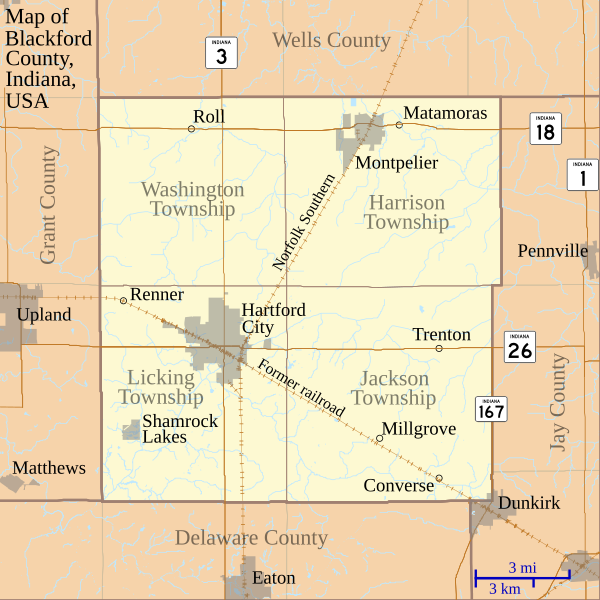
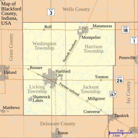
English: This is a map of Blackford County, Indiana, USA which shows settlements, county and township borders, and major transportation routes. |
| Datum | |
| Bron | My own work, using custom-written MapScript applications with freely-available United States Census Bureau TIGER data |
| Auteur | Omnedon |
Licentie
| Ik, de auteursrechthebbende van dit werk, geef dit werk vrij in het publieke domein. Dit is wereldwijd van toepassing. In sommige landen is dit wettelijk niet mogelijk; in die gevallen geldt: Ik sta iedereen toe dit werk voor eender welk doel te gebruiken, zonder enige voorwaarden, tenzij zulke voorwaarden door de wet worden voorgeschreven. |
Bestandsgeschiedenis
Klik op een datum/tijd om het bestand te zien zoals het destijds was.
| Datum/tijd | Miniatuur | Afmetingen | Gebruiker | Opmerking | |
|---|---|---|---|---|---|
| huidige versie | 3 jul 2011 00:49 | | 768 × 768 (508 kB) | Omnedon | == {{int:filedesc}} == {{Information |Description={{en|This is a map of Blackford County, Indiana, USA which shows settlements, county and township borders, and major transportation routes.}} |Source=My own work, using cus |
| 20 jun 2011 06:14 |  | 768 × 768 (506 kB) | Omnedon | == {{int:filedesc}} == {{Information |Description={{en|This is a map of Blackford County, Indiana, USA which includes incorporated settlement and township borders.}} |Source=My own work, using custom-written [http://www.ma | |
| 18 feb 2008 01:28 |  | 768 × 768 (29 kB) | Omnedon | {{Information |Description={{en|This is a map of Blackford County, Indiana, USA which shows settlements, townships, roads, railroads, and major rivers.}} |Source=My own work, using freely-available shape data and custom-written MapScript applications |Dat |
Bestandsgebruik
Dit bestand wordt op de volgende pagina gebruikt:
Globaal bestandsgebruik
De volgende andere wiki's gebruiken dit bestand:
- Gebruikt op ar.wikipedia.org
- Gebruikt op ceb.wikipedia.org
- Gebruikt op en.wikipedia.org
- Blackford County, Indiana
- Converse, Blackford County, Indiana
- Matamoras, Indiana
- Millgrove, Indiana
- Renner, Indiana
- Roll, Indiana
- Trenton, Indiana
- History of Hartford City, Indiana
- First Presbyterian Church (Hartford City, Indiana)
- Hartford City Courthouse Square Historic District
- Blackford County Courthouse
- Module:Location map/data/USA Indiana Blackford County/doc
- Montpelier Carnegie Library
- Module:Location map/data/USA Indiana Blackford County
- Gebruikt op es.wikipedia.org
- Gebruikt op fa.wikipedia.org
- Gebruikt op fr.wikipedia.org
- Gebruikt op kn.wikipedia.org
- Gebruikt op ro.wikipedia.org
- Gebruikt op si.wikipedia.org
- Gebruikt op tr.wikipedia.org
- Gebruikt op war.wikipedia.org


