
Bestand:Malaysia relief location map.jpg
Grootte van deze voorvertoning: 800 × 305 pixels. Andere resoluties: 320 × 122 pixels | 1.200 × 457 pixels.
Oorspronkelijk bestand (1.200 × 457 pixels, bestandsgrootte: 396 kB, MIME-type: image/jpeg)
Beschrijving
| Beschrijving |
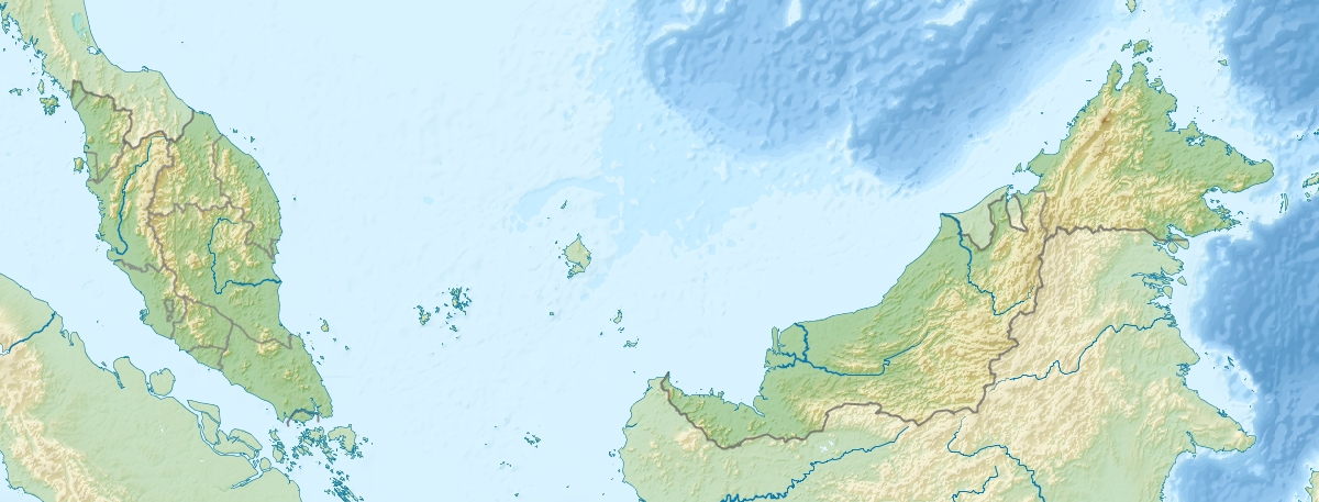
English: Location map of Malaysia.
Equirectangular projection. Strechted by 100.0%. Geographic limits of the map: * N: 8.0° N * S: 0.0° N * W: 99.0° E * E: 120.0° EMade with Natural Earth. Free vector and raster map data @ naturalearthdata.com. |
| Datum | |
| Bron | Eigen werk |
| Auteur | Uwe Dedering |
| Andere versies |
|
Licentie
Ik, de auteursrechthebbende van dit werk, maak het hierbij onder de volgende licenties beschikbaar:
Dit bestand is gelicenseerd onder de Creative Commons-licentie Naamsvermelding-Gelijk delen 3.0 Unported
- De gebruiker mag:
- Delen – het werk kopiëren, verspreiden en doorgeven
- Remixen – afgeleide werken maken
- Onder de volgende voorwaarden:
- naamsvermelding – U moet op een gepaste manier aan naamsvermelding doen, een link naar de licentie geven, en aangeven of er wijzigingen in het werk zijn aangebracht. U mag dit op elke redelijke manier doen, maar niet zodanig dat de indruk wordt gewekt dat de licentiegever instemt met uw werk of uw gebruik van zijn werk.
- Gelijk delen – Als u het werk heeft geremixt, veranderd, of erop heeft voortgebouwd, moet u het gewijzigde materiaal verspreiden onder dezelfde licentie als het oorspronkelijke werk, of een daarmee compatibele licentie.

|
Toestemming wordt verleend voor het kopiëren, verspreiden en/of wijzigen van dit document onder de voorwaarden van de GNU-licentie voor vrije documentatie, versie 1.2 of enige latere versie als gepubliceerd door de Free Software Foundation; zonder Invariant Sections, zonder Front-Cover Texts, en zonder Back-Cover Texts. Een kopie van de licentie is opgenomen in de sectie GNU-licentie voor vrije documentatie. |
U mag zelf één van de licenties kiezen.
Bestandsgeschiedenis
Klik op een datum/tijd om het bestand te zien zoals het destijds was.
| Datum/tijd | Miniatuur | Afmetingen | Gebruiker | Opmerking | |
|---|---|---|---|---|---|
| huidige versie | 24 apr 2010 11:38 | 1.200 × 457 (396 kB) | Uwe Dedering | {{Information |Description={{en|1=Location map of Malaysia. Equirectangular projection. Strechted by 100.0%. Geographic limits of the map: * N: 8.0° N * S: 0.0° N * W: 99.0° E * E: 120.0° E Made with Natural Earth. Free vector and raster map dat |
Bestandsgebruik
Dit bestand wordt op de volgende 13 pagina's gebruikt:
Globaal bestandsgebruik
De volgende andere wiki's gebruiken dit bestand:
- Gebruikt op ace.wikipedia.org
- Gebruikt op ar.wikipedia.org
- Gebruikt op ast.wikipedia.org
- Gebruikt op az.wikipedia.org
- Cohor boğazı
- Şablon:Nişanlama siyahısı
- Şablon:Yer xəritəsi Malayziya
- Kinabalu Milli Parkı
- Şablon:Nişanlama siyahısı/doc
- Malay yarımadası
- Endau-Rompin Milli Parkı
- Kinabalu
- Piay burnu
- Liqitan adası
- Mabul adası
- Ligitan arxipelaqı
- Kapalay adası
- Ketam adası
- Banqi adası
- Klanq adası
- Sebatik adası
- Sipadan adası
- Lanqkavi adaları
- Pinanq adası
- Malayziya coğrafiyası
- Gebruikt op ban.wikipedia.org
- Gebruikt op ba.wikipedia.org
- Gebruikt op bcl.wikipedia.org
- Gebruikt op be.wikipedia.org
- Gebruikt op bg.wikipedia.org
Globaal gebruik van dit bestand bekijken.


