
Bestand:Habomai islands-demis.png
Habomai_islands-demis.png (291 × 178 pixels, bestandsgrootte: 5 kB, MIME-type: image/png)
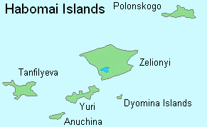
Map of the Russian rock islandgroup Habomai, part of the Lesser Kuril Islands just to the northeast of the Japanese island Hokkaido. The islands are claimed by Japan together with the islands Iturup, Kunashir, and Shikotan under the Shimoda Treaty of 1855 (see Image:Kurilenkonflikt.png).
Not shown are the smaller rock islandgroup Oskolki (Kira, Petshernaya, Svetsya, and Parus, the Lishi Islands, and Shishki Islands), and the rocks Signalny, Rifofy, Stozozheny, and Udivitelnaya.
Deze afbeelding bevindt zich in het publiek domein omdat ze afkomstig is van de website https://www.demis.nl/products/web-map-server/examples/ en is vrijgegeven door de copyright-houder. Het is toegestaan om deze kaart te kopiëren, verspreiden en/of aan te passen aangezien ze gebaseerd is op auteursrechtenvrije gegevens van: www.demis.nl. Zie ook toestemmingsemail op de.wp en een verklaring.
|
| This work has been released into the public domain by its copyright holder, www.demis.nl. This applies worldwide. In sommige landen is dit wettelijk niet mogelijk; in die gevallen geldt: www.demis.nl staat iedereen toe dit werk voor eender welk doel te gebruiken, zonder enige voorwaarden, tenzij zulke voorwaarden door de wet worden voorgeschreven.
|
Bestandsgeschiedenis
Klik op een datum/tijd om het bestand te zien zoals het destijds was.
| Datum/tijd | Miniatuur | Afmetingen | Gebruiker | Opmerking | |
|---|---|---|---|---|---|
| huidige versie | 26 nov 2006 18:36 | | 291 × 178 (5 kB) | Hardscarf | Map of the Russian rock islandgroup Habomai, part of the Lesser Kuril Islands just to the northeast of the Japanese island Hokkaido. The islands are claimed by Japan together with the islands Iturup, Kunashir, and Shikotan under the Shimoda Treaty of |
Bestandsgebruik
Dit bestand wordt op de volgende 3 pagina's gebruikt:
Globaal bestandsgebruik
De volgende andere wiki's gebruiken dit bestand:
- Gebruikt op cs.wikipedia.org
- Gebruikt op de.wikipedia.org
- Gebruikt op eo.wikipedia.org
- Gebruikt op fi.wikipedia.org
- Gebruikt op it.wikipedia.org


