
Bestand:Breda-centrum-OpenTopo.jpg
Grootte van deze voorvertoning: 645 × 599 pixels. Andere resoluties: 258 × 240 pixels | 517 × 480 pixels | 826 × 768 pixels | 1.102 × 1.024 pixels | 2.204 × 2.048 pixels | 6.164 × 5.728 pixels.
Oorspronkelijk bestand (6.164 × 5.728 pixels, bestandsgrootte: 9,03 MB, MIME-type: image/jpeg)
Beschrijving
| Beschrijving |
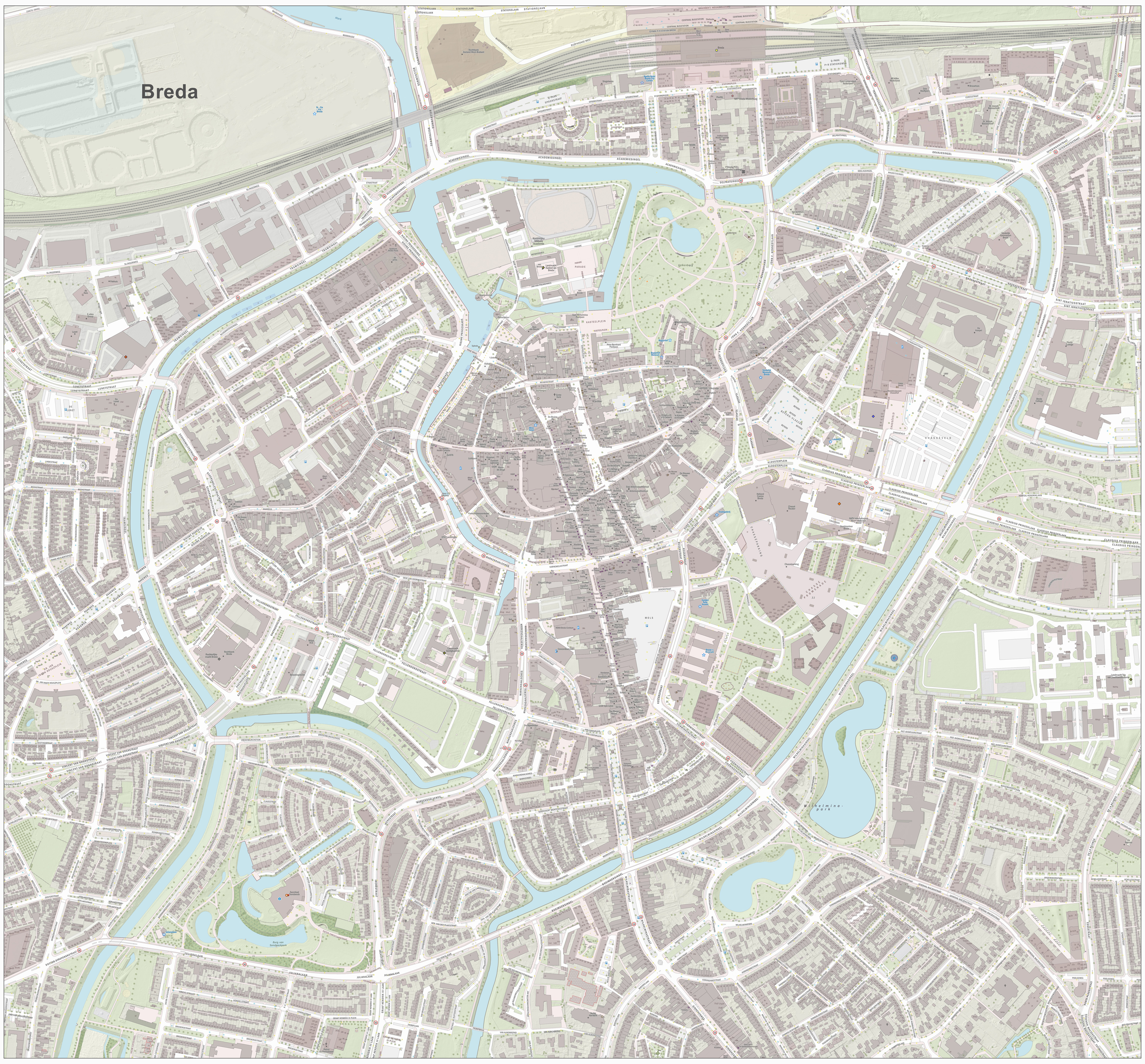
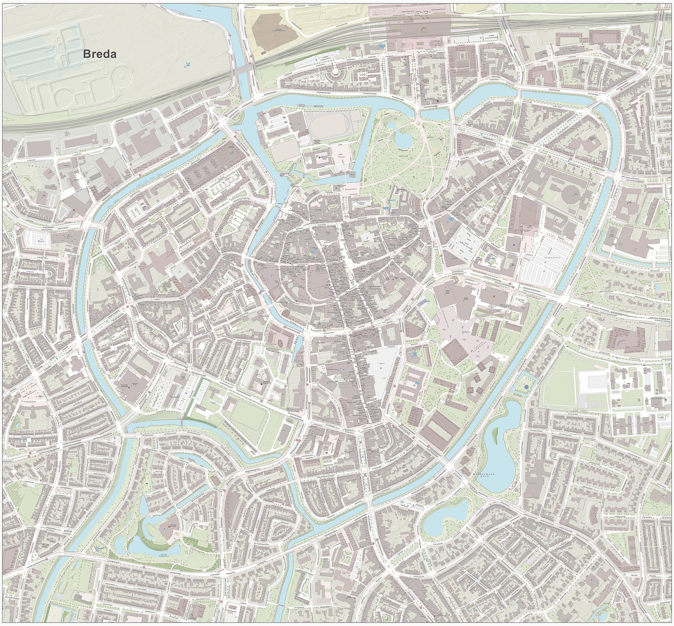
Nederlands: Topografische kaart van Breda (centrum van woonplaats). Resolutie: 2688 pixels/km.
Kaartbeeld samengesteld uit de open geodata van de Basisregistratie Grootschalige Topografie (BGT), Creative Commons-BY Kadaster, en Top10NL en Top25namen (Basisregistratie Topografie, Kadaster), Creative Commons-BY Kadaster. Gebouwvlakken uit open geodata BAG extract, Creative Commons-BY Kadaster. Wegen uit de OpenStreetMap, CC-BY OpenStreetMap bijdragers. Reliëfschaduw uit de Actuele Hoogtekaart AHN2/AHN3. Samenstelling en kleurenschema: Jan-Willem van Aalst, met QGIS2. Zie ook de Legenda. |
| Datum | |
| Bron | Eigen werk |
| Auteur | Janwillemvanaalst |
Licentie
Ik, de auteursrechthebbende van dit werk, maak het hierbij onder de volgende licentie beschikbaar:
Dit bestand is gelicenseerd onder de Creative Commons Naamsvermelding-GelijkDelen 4.0 Internationaal licentie.
- De gebruiker mag:
- Delen – het werk kopiëren, verspreiden en doorgeven
- Remixen – afgeleide werken maken
- Onder de volgende voorwaarden:
- naamsvermelding – U moet op een gepaste manier aan naamsvermelding doen, een link naar de licentie geven, en aangeven of er wijzigingen in het werk zijn aangebracht. U mag dit op elke redelijke manier doen, maar niet zodanig dat de indruk wordt gewekt dat de licentiegever instemt met uw werk of uw gebruik van zijn werk.
- Gelijk delen – Als u het werk heeft geremixt, veranderd, of erop heeft voortgebouwd, moet u het gewijzigde materiaal verspreiden onder dezelfde licentie als het oorspronkelijke werk, of een daarmee compatibele licentie.
Bestandsgeschiedenis
Klik op een datum/tijd om het bestand te zien zoals het destijds was.
| Datum/tijd | Miniatuur | Afmetingen | Gebruiker | Opmerking | |
|---|---|---|---|---|---|
| huidige versie | 1 mei 2017 20:58 | | 6.164 × 5.728 (9,03 MB) | Janwillemvanaalst | Higher resolution rendering, combining elements of the new Dutch Base Registry of Large-scale Topography (BGT), CC-BY Dutch Kadaster. Also incorporated: elements of the OpenStreetMap (OSM), CC-BY OSM contributors. |
| 14 mei 2016 18:21 |  | 1.824 × 1.582 (2,15 MB) | Janwillemvanaalst | Error correction on terrain and labels, May 2016 | |
| 7 mei 2016 16:50 |  | 1.960 × 1.729 (2,5 MB) | Janwillemvanaalst | Map layers update, April 2016 | |
| 20 dec 2014 13:18 |  | 1.588 × 1.336 (1,38 MB) | Janwillemvanaalst | User created page with UploadWizard |
Bestandsgebruik
Dit bestand wordt op de volgende 11 pagina's gebruikt:
Globaal bestandsgebruik
De volgende andere wiki's gebruiken dit bestand:
- Gebruikt op de.wikipedia.org
- Gebruikt op fr.wikipedia.org
- Gebruikt op fy.wikipedia.org


